
")
 UPSC Exams
  UPSC CSE
 UPSC CAPF
 UPSC CDS
 UPSC NDA
 UPSC EPFO
 UPSC CISF LDCE
 State Upper PCS
  UPPSC PCS
 BPSC CCE
 RPSC RAS
 MPPSC (Madhya Pradesh) CCE
 MPSC (Maharasthra) Rajyaseva
 WBPSC WBCS
 GPSC CCE
 KPSC (Karnataka) KAS
 APSC (Assam) CCE
 View More
 Defence
 AFCAT
AFCAT BSF SI
 Indian Army Agniveer
 Banking
  IBPS PO
 SBI PO
 RBI Grade B
 Cental Bank Of India Apprentice
 IDBI Junior Assistant Manager
 SSC
SSC  Police
  Bihar Police SI
 UP Police SI
 Delhi Police Head Constable
 Rajasthan Police SI
 WB Police SI
 Assam Police SI
 Odisha Police SI
 Railway
 Other State Exams
 Insurance
 Regulatory Body
Geographical Structure of Kerala
The three physiographic divisions of Kerala are the lowlands, midlands, and highlands based on Altitude above Sea Level
1. Physiographic Divisions of Kerala
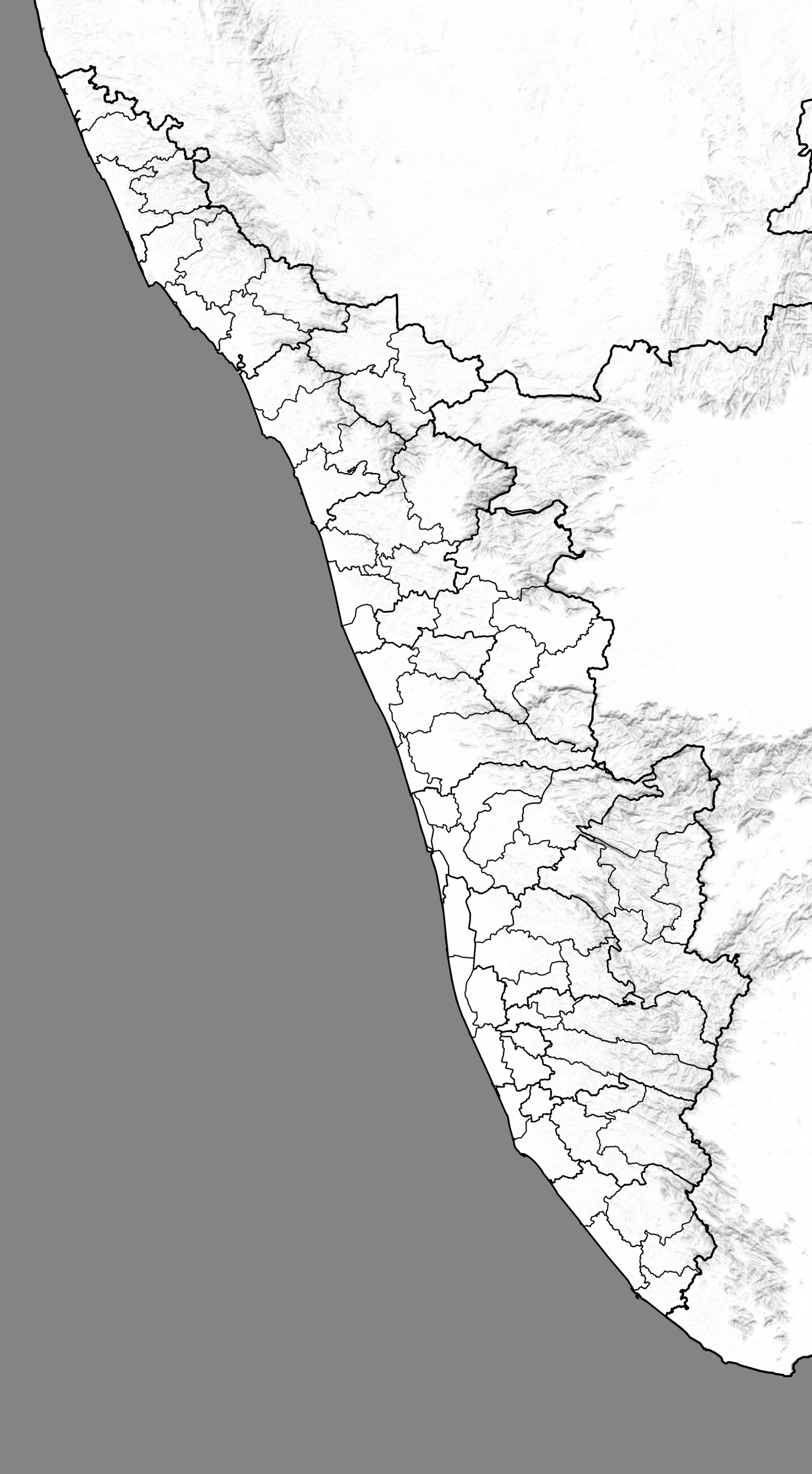
Kasargod
Kannur
Kozhikode
Wayanad
Malapuram
Palakkad
Thrissur
Ernakulam
Idduki
Kottayam
Alappuzha
Pathanamthitta
Kollam
Thiruvananthapuram
Lowland Region
Manjeshwaram
Kasargod
Hosdurg
Palakkad
Taliparamba
Kannur
Thalassery
Vadakara
Quilandy
Thamarassery
Kozhikode
Mananthavady
Sulthanbathery
Vythiri
Nilambur
Eranad
Tirurangadi
Neyyattinkara
Kattakkada
Thiruvananthapuram
Nedumangad
Chirayinkeezhu
Kottarakkara
Punalur
Pathanapuram
Kollam
Kurunagappally
Kunnathur
Adoor
Kozhenchery (Pathanamthitta)
Ranni
Thiruvalla
Mallappally
Mavelikkara
Chengannur
Karthikappally
Kuttanad
Ambalappuzha
Cherthala
Changanassery
Kottayam
Kanjirappally
Meenachil
Vaikom
Peerumade
Devikulam
Kothamangalam
Talappilly
Mannarkad
Ottappalam
Pattambi
Alathur
Chittur
Ponnani
Tirur
Perinthalmanna
Chalakkudi
Koungattur
Thrissur
Thalapilly
Chavakkad
Paravur
Kanayannur
Kunnathunad
Muvattupuzha
Kochi
Udumbanchola
Idukki
Thodupuzha
Vellarikkundu
Payyanur
Iritty
Location and Districts Covered
The lowland areas of Kerala are primarily covered by the coastal districts including Thiruvananthapuram, Kollam, Alappuzha, Kottayam, Ernakulam, Thrissur, Malappuram, Kozhikode, Kannur, and Kasaragod
Width and Elevation
The lowlands of Kerala generally lie below 7.5 meters above sea level, making up the coastal region of the state, with a width varying between 11km and 124km depending on the location along the coastline
Formation
The lowlands of Kerala were primarily formed by the deposition of sediments brought down by rivers from the Western Ghats, creating a coastal plain along the Arabian Sea, with the majority of this land being formed through the upliftment of the continental shelf over time, resulting in a “structural plain”
Soil Type and Vegetation
The soil types in the lowlands of Kerala include coastal alluvium, mixed alluvium, and acid saline soils.
The lowlands of Kerala have marshes, mangroves, coconut groves. Paddy fields are widely cultivated in the lowlands, particularly in areas like Kuttanad.
Climate
The climate of the lowlands in Kerala is typically classified as tropical wet and humid, characterized by hot and humid weather for most of the year, with heavy monsoon rainfall during the rainy season due to the influence of the Western Ghats
Other Features
The rivers Bharathapuzha, Periyar, and Pamba flow through the lowlands of Kerala, and the backwaters include Vembanad, Biyyam, and Manoor.
2. Hill Ranges and Plateaus of Kerala [Including Top Peaks] from North to South ↓
Location
Brahmagiri, is a mountain range in the Western Ghats of south India. It is situated on the border between Kodagu district in Karnataka state in the north and Wayanad district of Kerala state on the south
Topography
The height of Brahmagiri ranges from 1,234 meters to 1,298 meters depending on the location and source.
Important Features
The highest point in the Brahmagiri range is Brahmagiri peak, which is 1,607 meters (m) tall.
Talakaveri (Source Point of Kaveri) is located on the northern section of the range, near Bhagamandala in Kodagu district.
Pakshipathalam Bird Sanctuary is a bird sanctuary and a tourist location
Thirunelli Temple, dedicated to Lord Vishnu, lies on the Kerala side of Brahmagiri.
Iruppu (or Irpu or Lakshmana Tirtha) Falls of the Lakshmana Tirtha River lies on the Karnataka side of Brahmagiri.
Location
The Wayanad Plateau is located in the north-east of Kerala state in the Wayanad district , It is actually is a continuation of the Mysore Plateau, which is part of the Deccan Plateau
Topography
Its Height is Between 700 and 2,100 meters above sea level. The plateau of Wayanad slopes down eastwards and if you travel further from Mananthavady, it becomes a common plain of paddy fields
Important Features
Chembra Peak, standing tall at an elevation of about 2,100 meters (6,890 feet), is the highest peak
Location
The Attappady plateau is a scenic valley in the Western Ghats In the Palakkad district of Kerala . Between the Nilgiri Hills and Palghat Gap
Topography
This block of compact high mountains between 1200m-2000m which is floristically and faunistically similar to the Nilgiri Hills.
Important Features
The tallest peak in this range is called Vavul Mala. At an elevation of 2,339 m (7,674 ft), it is the tallest of the Western Ghats to the north of Nilgiri Hills and lies on the border between Kozhikode and Malappuram districts
Location
Most of the hill range falls in the Meppadi Forest Range of South Wayanad Division, with some parts falling in the Thamarassery Range of Kozhikode Division. They are semi-contiguous with Nilgiris or Nilgiri Hills in Tamil Nadu, separated by the Chaliyar Valley.
Topography
This block of compact high mountains between 1200m-2000m which is floristically and faunistically similar to the Nilgiri Hills.
Important Features
The tallest peak in this range is called Vavul Mala. At an elevation of 2,339 m (7,674 ft), it is the tallest of the Western Ghats to the north of Nilgiri Hills and lies on the border between Kozhikode and Malappuram districts
Location
Southern Western Ghats of central Kerala and span the border of western Tamil Nadu in Southern India. They are spread largely over Palakkad district, Thrissur district, Ernakulam district and Idukki district of Kerala(mainly Palakkad and Idukki), Tamil Nadu’s Coimbatore district and Tiruppur district.
Topography
Its Height is Between 700 and 2,100 meters above sea level. The plateau of Wayanad slopes down eastwards and if you travel further from Mananthavady, it becomes a common plain of paddy fields
High Points
Anamudi Peak (8,842 feet (2,695 metres)) lies at the southern end of the range and is the highest peak in southern India.
Important Features
3. Mountain Passes of Kerala
Location
Bundelkhand Region, Madhya Pradesh
Connecting Regions
Jawara Dance has deep roots in the agrarian culture of Bundelkhand. It has been performed for centuries by farming communities to express gratitude to the gods for a bountiful harvest. The dance is symbolic of the prosperity and happiness brought by successful agricultural seasons.
Important Features
Jawara Dance has deep roots in the agrarian culture of Bundelkhand. It has been performed for centuries by farming communities to express gratitude to the gods for a bountiful harvest. The dance is symbolic of the prosperity and happiness brought by successful agricultural seasons.