
")
 UPSC Exams
  UPSC CSE
 UPSC CAPF
 UPSC CDS
 UPSC NDA
 UPSC EPFO
 UPSC CISF LDCE
 State Upper PCS
  UPPSC PCS
 BPSC CCE
 RPSC RAS
 MPPSC (Madhya Pradesh) CCE
 MPSC (Maharasthra) Rajyaseva
 WBPSC WBCS
 GPSC CCE
 KPSC (Karnataka) KAS
 APSC (Assam) CCE
 View More
 Defence
 AFCAT
AFCAT BSF SI
 Indian Army Agniveer
 Banking
  IBPS PO
 SBI PO
 RBI Grade B
 Cental Bank Of India Apprentice
 IDBI Junior Assistant Manager
 SSC
SSC  Police
  Bihar Police SI
 UP Police SI
 Delhi Police Head Constable
 Rajasthan Police SI
 WB Police SI
 Assam Police SI
 Odisha Police SI
 Railway
 Other State Exams
 Insurance
 Regulatory Body
Exogenic Geomorphic Processes [Erosional and Depositional]
Land surfaces are sculpted into a wide diversity of shapes through Erosion and Deposition by the actions of water, wind, waves, ice, etc
1. Fluvial Landforms
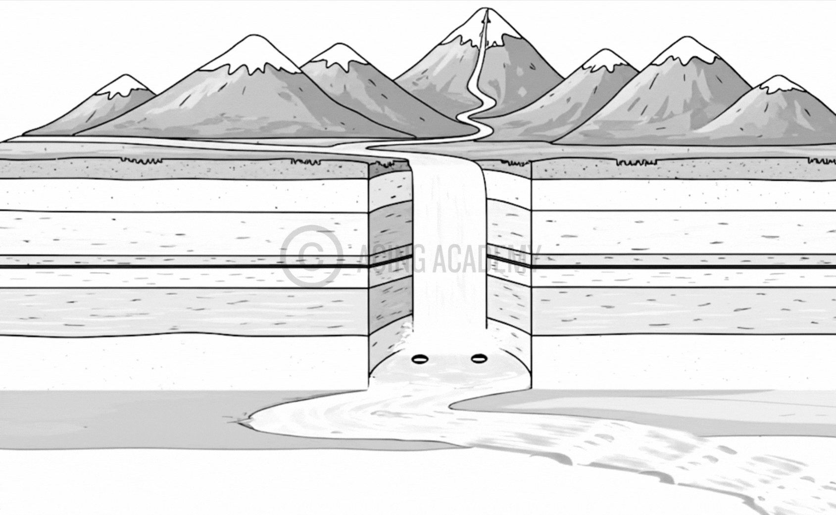
Fluvial landforms are those generated by running water, mainly rivers. The term fluvial derives from the Latin word ‘fluvius’ that means river. Fluvial landforms cover an enormous range of dimensions, from small features like rills to major continental-scale morpho-hydrological units like large rivers and their drainage basins. Rivers flowing to the oceans drain about 68 % of the Earth’s land surface. The source of the river is generally found in an upland region with a slope down for the run-offs. Hence, the uplands form the catchment areas of the rivers & the crest of mountains becomes the divide or watershed from which the streams flow down the slope.
River Capture

Pot Holes

Plunge Pools

V - Shaped Valley


U - Shaped Valley

Rapids and Cataracts

River Terraces

River Capture
A strong river diverts a weak river from its path, and makes it to flow along with it. River capture happens when one river, typically a stronger or faster-flowing one, erodes its way into the drainage basin of a neighboring river, diverting the water from the weaker river and essentially “capturing” its flow, often through a process called headward erosion where the capturing river extends its channel upstream towards the other river’s headwaters, eventually diverting the water into its own course.
V Shaped / U shaped Valley
V-shaped valley is a narrow valley with steeply sloped side. When the valley floor flattens out, Forming U shape its called a U- Shaped Valley. A V-shaped valley is formed by the erosive action of a river, where the flowing water cuts deep into the land, creating steep sides that meet at a point. As the cycle attains maturity, the lateral erosion (makes river wider) becomes prominent and the valley floor flattens out, Forming U shape
Difference with Gorge / Canyon ?
A “gorge” is a smaller, narrower version of a V-shaped valley with steep sides, while a “canyon” is a much larger, deeper V-shaped valley
Pot Holes and Plunge Pools
While potholes are smaller, circular depressions in a riverbed plunge pools are large, deep depressions at the base of a waterfall. Concentrated force of falling water carrying pebbles grind against the rock surface create these depressions
Rapids and Cataracts
Rapids and cataracts are both features of rivers that involve fast-moving water and obstacles. They are essentially circular movement of water. Cataracts are steeper rapids. Due to the unequal resistance of hard and soft rocks traversed by a river, the outcrop of a band of hard rock may cause a river to ‘jump’ or ‘fall’ down stream in a circular motion.
Terraces
Stepped benches along the river course in flood plains. River terraces are basically products of erosion as they result due to vertical erosion by the stream into its own depositional floodplain.
Rills and Gullies
Slow movement of water creates small channels called rills which become larger to form gullies. They are typically formed in arid areas. Arid environments often have limited vegetation cover, leaving the soil exposed and more vulnerable to erosion by water runoff. As rills develop, they can channel more water into a smaller area, deepening and widening the channel, eventually forming a gully.
Drainage Basin
Streams and rivers and the land surface, all are included in the drainage basin. The drainage basin collects all the water within the basin and directs it to a single point. That is why it is also referred to as a funnel
Oxbow Lake

Point Bar

Cut Banks
Natural Levees

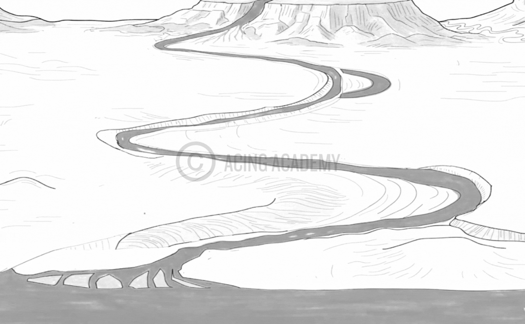
Meander

Alluvial Fan

Deltas and Estuaries


Alluvial Fan
An alluvial fan is a fan-shaped deposit of sediment that forms at the base of mountains or hills. An alluvial fan forms when a stream of water carrying sediment, called alluvium, exits a narrow passage like a canyon or mountain gap onto a flat plain, causing the water to slow down and spread out, depositing the sediment in a fan-shaped pattern as the heavier particles settle first, followed by lighter ones, creating the distinctive fan-like landform.
River Meander
A river meander is a bend or curve in a river that forms a snake-like pattern.A river meander forms when the flowing water in a river erodes the outer banks of a bend due to faster water velocity, causing sediment to be deposited on the inner banks of the bend, gradually creating a curving pattern as the river’s path evolves over time.
Oxbow Lake
An oxbow lake is a U-shaped or crescent-shaped lake that forms when a river’s meander is cut off. An oxbow lake forms when a meandering river’s loop gets cut off due to erosion and deposition, creating a separate body of water; the stages include:
(1) Meandering river with pronounced bends,
(2) Increased erosion on the outer bends of the meanders,
(3) Deposition on the inner bends narrowing the “neck” of the loop,
(4) The neck erodes through, the river takes a straighter path, and the loop is isolated as an oxbow lake.
Natural Levees
A natural levee is a ridge of sand and mud that forms along a riverbank. When a river floods, it carries sediment with it. Over time, these deposits build up to form raised ridges that act as barriers along the river. Levees can also be artificially constructed from fill to regulate water levels.
Point Bars and Cut Banks
A point bar is a crescent-shaped ridge of sand and gravel that forms on the inside bend of a river or stream. The outside curve of a river meander, where erosion is greatest forms a small cliff. [ Note Cut Bank is Erosional Landform]. A point bar forms when a river’s flow slows down along the inside curve of a meander, causing sediment to deposit and build up over time, creating a low, curved ridge of sand and gravel on the inner bank of the river. Essentially, the slower water on the inside of the bend can’t carry as much sediment, leading to deposition and the formation of a point bar, while the faster water on the outside of the bend erodes the bank, creating a cut bank.
River Delta
A river delta is a landform that forms at the mouth of a river where it deposits sediment and meets a larger body of water. An Estuary on the other hand is a coastal body of water formed on mixing of freshwater and saltwater. A delta is formed when a river with large bedload slows down and then spreads into number of distributaries depositing its sediment where the continental shelf is wide. An Estuary on the other hand is formed at river mouth when a river does not deposit large amounts of sediments at its mouth and has large influence of tides, (the regular rise and fall of tides allows seawater to move into the river mouth, forming the estuary)
Types of River Deltas
Arcuate : This type of delta results when light depositions give rise to shallow, shifting distributaries Nile, Ganga, Indus.
Birdfoot: This type of delta emerges when limestone sediment deposits do not allow downward seepage of water distributaries seem to be flowing over projections of these deposits. Mississippi river
Cuspate: This is a pointed delta formed generally along strong coasts and is subjected to strong wave action. There are very few distributaries in a cuspate delta. Hudson estuary
1. Fluvial Landforms
1.1 Erosional Fluvial Landforms
What is it ?
A strong river diverts a weak river from its path, and makes it to flow along with it.
Formation
River capture happens when one river, typically a stronger or faster-flowing one, erodes its way into the drainage basin of a neighboring river, diverting the water from the weaker river and essentially “capturing” its flow, often through a process called headward erosion where the capturing river extends its channel upstream towards the other river’s headwaters, eventually diverting the water into its own course.
What is it ?
V-shaped valley is a narrow valley with steeply sloped side. When the valley floor flattens out, Forming U shape its called a U- Shaped Valley.
Formation
A V-shaped valley is formed by the erosive action of a river, where the flowing water cuts deep into the land, creating steep sides that meet at a point. As the cycle attains maturity, the lateral erosion (makes river wider) becomes prominent and the valley floor flattens out, Forming U shape
Difference with Gorge / Canyon
A “gorge” is a smaller, narrower version of a V-shaped valley with steep sides, while a “canyon” is a much larger, deeper V-shaped valley
What is it ?
While potholes are smaller, circular depressions in a riverbed plunge pools are large, deep depressions at the base of a waterfall.
Formation
Concentrated force of falling water carrying pebbles grind against the rock surface create these depressions
What is it ?
Rapids and cataracts are both features of rivers that involve fast-moving water and obstacles. They are essentially circular movement of water. Cataracts are steeper rapids.
Formation
Due to the unequal resistance of hard and soft rocks traversed by a river, the outcrop of a band of hard rock may cause a river to ‘jump’ or ‘fall’ down stream in a circular motion.
What is it ?
Stepped benches along the river course in flood plains.
Formation
River terraces are basically products of erosion as they result due to vertical erosion by the stream into its own depositional floodplain..
What is it ?
Slow movement of water creates small channels called rills which become larger to form gullies.
Formation
They are typically formed in arid areas. Arid environments often have limited vegetation cover, leaving the soil exposed and more vulnerable to erosion by water runoff. As rills develop, they can channel more water into a smaller area, deepening and widening the channel, eventually forming a gully.
1.2 Deposional Fluvial Landforms
What is it ?
An alluvial fan is a fan-shaped deposit of sediment that forms at the base of mountains or hills.
Formation
An alluvial fan forms when a stream of water carrying sediment, called alluvium, exits a narrow passage like a canyon or mountain gap onto a flat plain, causing the water to slow down and spread out, depositing the sediment in a fan-shaped pattern as the heavier particles settle first, followed by lighter ones, creating the distinctive fan-like landform.
What is it ?
A river meander is a bend or curve in a river that forms a snake-like pattern.
Formation
A river meander forms when the flowing water in a river erodes the outer banks of a bend due to faster water velocity, causing sediment to be deposited on the inner banks of the bend, gradually creating a curving pattern as the river’s path evolves over time.
What is it ?
An oxbow lake is a U-shaped or crescent-shaped lake that forms when a river’s meander is cut off.
Formation
An oxbow lake forms when a meandering river’s loop gets cut off due to erosion and deposition, creating a separate body of water; the stages include:
(1) Meandering river with pronounced bends,
(2) Increased erosion on the outer bends of the meanders,
(3) Deposition on the inner bends narrowing the “neck” of the loop,
(4) The neck erodes through, the river takes a straighter path, and the loop is isolated as an oxbow lake.
What is it ?
A natural levee is a ridge of sand and mud that forms along a riverbank.
Formation
When a river floods, it carries sediment with it. Over time, these deposits build up to form raised ridges that act as barriers along the river. Levees can also be artificially constructed from fill to regulate water levels.
What is it ?
A point bar is a crescent-shaped ridge of sand and gravel that forms on the inside bend of a river or stream. The outside curve of a river meander, where erosion is greatest forms a small cliff.
Formation
A point bar forms when a river’s flow slows down along the inside curve of a meander, causing sediment to deposit and build up over time, creating a low, curved ridge of sand and gravel on the inner bank of the river. Essentially, the slower water on the inside of the bend can’t carry as much sediment, leading to deposition and the formation of a point bar, while the faster water on the outside of the bend erodes the bank, creating a cut bank.
What is it ?
A river delta is a landform that forms at the mouth of a river where it deposits sediment and meets a larger body of water. An Estuary on the other hand is a coastal body of water formed on mixing of freshwater and saltwater.
Formation
A delta is formed when a river with large bedload slows down and then spreads into number of distributaries depositing its sediment where the continental shelf is wide. An Estuary on the other hand is formed at river mouth when a river does not deposit large amounts of sediments at its mouth and has large influence of tides, (the regular rise and fall of tides allows seawater to move into the river mouth, forming the estuary)
1.2 Karst Landforms
- Karst is a topography formed from the dissolution of soluble rocks such as limestone, dolomite, and gypsum. It is characterized by underground drainage systems with sinkholes and caves.
- Karst is most strongly developed in dense carbonate rock, such as limestone, that is thinly bedded and highly fractured.
- Karst is not typically well developed in chalk, because chalk is highly porous rather than dense, so the flow of groundwater is not concentrated along with fractures.
- Karst is also most strongly developed where the water table is relatively low, such as in uplands with entrenched valleys, and where rainfall is moderate to heavy. This contributes to the rapid downward movement of groundwater, which promotes the dissolution of the bedrock, whereas standing groundwater becomes saturated with carbonate minerals and ceases to dissolve the bedrock.
- Karsts are found in widely scattered sections of the world, including the Causses of France; the Kwangsi area of China; the Yucatán Peninsula; and the Middle West, Kentucky, and Florida in the United States.
- In India karst topography is present in the Vindhya region (mainly southwestern Bihar), the Himalayas (parts of Jammu & Kashmir, Robert Cave, Sahasradhara, the eastern Himalayas, areas near Dehradun), Pachmarhi in Madhya Pradesh, Gupt GodavariCave in Chitrakoot (U.P.), the surrounding coast near Vishakhapatnam(Borra Caves), and Bastar in Chhattisgarh.
- Borra Caves – Borra Caves, also called Borra Guhalu, are located on the East Coast of India, in the Ananthagiri hills of the Araku Valley.
River Capture
A strong river diverts a weak river from its path, and makes it to flow along with it. River capture happens when one river, typically a stronger or faster-flowing one, erodes its way into the drainage basin of a neighboring river, diverting the water from the weaker river and essentially “capturing” its flow, often through a process called headward erosion where the capturing river extends its channel upstream towards the other river’s headwaters, eventually diverting the water into its own course.
V Shaped / U shaped Valley
V-shaped valley is a narrow valley with steeply sloped side. When the valley floor flattens out, Forming U shape its called a U- Shaped Valley. A V-shaped valley is formed by the erosive action of a river, where the flowing water cuts deep into the land, creating steep sides that meet at a point. As the cycle attains maturity, the lateral erosion (makes river wider) becomes prominent and the valley floor flattens out, Forming U shape
Difference with Gorge / Canyon ?
A “gorge” is a smaller, narrower version of a V-shaped valley with steep sides, while a “canyon” is a much larger, deeper V-shaped valley
Pot Holes and Plunge Pools
While potholes are smaller, circular depressions in a riverbed plunge pools are large, deep depressions at the base of a waterfall. Concentrated force of falling water carrying pebbles grind against the rock surface create these depressions
Rapids and Cataracts
Rapids and cataracts are both features of rivers that involve fast-moving water and obstacles. They are essentially circular movement of water. Cataracts are steeper rapids. Due to the unequal resistance of hard and soft rocks traversed by a river, the outcrop of a band of hard rock may cause a river to ‘jump’ or ‘fall’ down stream in a circular motion.
Terraces
Stepped benches along the river course in flood plains. River terraces are basically products of erosion as they result due to vertical erosion by the stream into its own depositional floodplain.
Rills and Gullies
Slow movement of water creates small channels called rills which become larger to form gullies. They are typically formed in arid areas. Arid environments often have limited vegetation cover, leaving the soil exposed and more vulnerable to erosion by water runoff. As rills develop, they can channel more water into a smaller area, deepening and widening the channel, eventually forming a gully.
Drainage Basin
Streams and rivers and the land surface, all are included in the drainage basin. The drainage basin collects all the water within the basin and directs it to a single point. That is why it is also referred to as a funnel
Alluvial Fan
An alluvial fan is a fan-shaped deposit of sediment that forms at the base of mountains or hills. An alluvial fan forms when a stream of water carrying sediment, called alluvium, exits a narrow passage like a canyon or mountain gap onto a flat plain, causing the water to slow down and spread out, depositing the sediment in a fan-shaped pattern as the heavier particles settle first, followed by lighter ones, creating the distinctive fan-like landform.
River Meander
A river meander is a bend or curve in a river that forms a snake-like pattern.A river meander forms when the flowing water in a river erodes the outer banks of a bend due to faster water velocity, causing sediment to be deposited on the inner banks of the bend, gradually creating a curving pattern as the river’s path evolves over time.
Oxbow Lake
An oxbow lake is a U-shaped or crescent-shaped lake that forms when a river’s meander is cut off. An oxbow lake forms when a meandering river’s loop gets cut off due to erosion and deposition, creating a separate body of water; the stages include:
(1) Meandering river with pronounced bends,
(2) Increased erosion on the outer bends of the meanders,
(3) Deposition on the inner bends narrowing the “neck” of the loop,
(4) The neck erodes through, the river takes a straighter path, and the loop is isolated as an oxbow lake.
Natural Levees
A natural levee is a ridge of sand and mud that forms along a riverbank. When a river floods, it carries sediment with it. Over time, these deposits build up to form raised ridges that act as barriers along the river. Levees can also be artificially constructed from fill to regulate water levels.
Point Bars and Cut Banks
A point bar is a crescent-shaped ridge of sand and gravel that forms on the inside bend of a river or stream. The outside curve of a river meander, where erosion is greatest forms a small cliff. [ Note Cut Bank is Erosional Landform]. A point bar forms when a river’s flow slows down along the inside curve of a meander, causing sediment to deposit and build up over time, creating a low, curved ridge of sand and gravel on the inner bank of the river. Essentially, the slower water on the inside of the bend can’t carry as much sediment, leading to deposition and the formation of a point bar, while the faster water on the outside of the bend erodes the bank, creating a cut bank.
River Delta
A river delta is a landform that forms at the mouth of a river where it deposits sediment and meets a larger body of water. An Estuary on the other hand is a coastal body of water formed on mixing of freshwater and saltwater. A delta is formed when a river with large bedload slows down and then spreads into number of distributaries depositing its sediment where the continental shelf is wide. An Estuary on the other hand is formed at river mouth when a river does not deposit large amounts of sediments at its mouth and has large influence of tides, (the regular rise and fall of tides allows seawater to move into the river mouth, forming the estuary)
Types of River Deltas
Arcuate : This type of delta results when light depositions give rise to shallow, shifting distributaries Nile, Ganga, Indus.
Birdfoot: This type of delta emerges when limestone sediment deposits do not allow downward seepage of water distributaries seem to be flowing over projections of these deposits. Mississippi river
Cuspate: This is a pointed delta formed generally along strong coasts and is subjected to strong wave action. There are very few distributaries in a cuspate delta. Hudson estuary
3.1 Wave Cut Landforms
Wave – Cut Landform
A wave-cut platform is a flat rock platform that forms at the base of a sea cliff.Waves erode a notch at the base of the cliff ➜ This overhanging rock falls ➜ The cliff material is deposited, forming a bedrock area
Sea Cliff
A sea cliff is a steep, vertical rock face that forms along the coast.Waves crash against the coastline, creating a notch. ➜ The erosion of the notch weakens the ground above it, causing it to collapse. ➜ The process of erosion and collapse repeats, causing the sea cliff to retreat. The highest sea cliffs in the world are on Molokai, Hawaii, and are 3,300 ft (1,010 m) tall
Sea Cave
A sea cave is a hollowed-out section of a cliff that forms along the ocean or lake shore. Sea caves are created by erosion from waves, which break on the rock and force water into areas of weakness in the rock.Matainaka Cave in New Zealand is the world’s largest sea cave, measuring 1.54 kilometers long. It’s located on the Otago coast of New Zealand’s South Island.
Sea Stack
When the waves attack a rock- form from two opposite sides, it produces a hollow bridge called an Arch, These archways may have an arcuate or rectangular shape, with the opening extending below water. These are formed due to different rates of erosion typically due to the varied resistance of bedrock.Xianren Bridge is a natural arch created by flowing water that has the world’s longest recorded span.
Terraces
A sea stack is a steep, isolated column of rock that stands in the ocean near the shore. Waves erode a natural hole through a headland, forming a sea arch➜ The base of the arch widens due to erosion➜ the roof collapses into the sea➜The remaining column of rock is a sea stack. Ball’s Pyramid is the world’s tallest sea stack, standing at 572 meters (1,877 ft) high & It’s located in the Pacific Ocean, 12 miles southeast of Lord Howe Island in Australia.
Sea Stump
A stump is the eroded remains of a stack, often looking like a lump of rock sticking up from its surroundings. The base of the stack is undercut by erosion until it collapses into a short pillar, called a stump
Blow Hole
A blowhole is a hole in the ground or rock that allows air or water to be forced through it. Blowholes can be found along the shore. Blowholes can form when sea caves grow upwards and landwards, creating vertical shafts. Waves can force air through these shafts, releasing pressure as a jet of spray.Blowholes can also form when there are pressure differences between a closed underground system and the surface.The Kiama Blowhole in Kiama, New South Wales, Australia is the world’s largest blowhole
Bay
A Bay is a recessed, coastal body of water that directly connects to a larger main body of water, such as an ocean, a lake, or another bay. A large bay is usually called a gulf. Waves erode the coastline, wearing away softer rocks more quickly than harder rocks. This creates bays, while harder rocks form headlands. The Bay of Bengal is the world’s largest bay, covering an area of about 839,000 square miles (2,173,000 square kilometers).It is located in the northeastern Indian Ocean. It is bordered by Sri Lanka and India to the west, Bangladesh to the north, and Myanmar (Burma) and the Malay Peninsula to the east.
Chasm
Sand Bar
Introduction
The sandbar is the ridge of sand or coarse sediment that is built over a period of time by the waves
Formation
It is formed by the process of longshore drift, which is when sediment is moved along a shoreline due to the action of waves and currents. ➜ This creates a ridge or bar of sediment overtime
Sand Spit
Introduction
Barrier bar which gets keyed up to one end of bay creating a hook is called spit. This Hook is generally toward the quieter waters close to shore.
Formation
These are formed just in the same way a Sand Bar forms. A hooked end can form if the wind direction changes.
Barrier Island
Introduction
When a long, narrow ridge of sand Island, runs parallel to the shore often separating a shallow lagoon or bay from the open ocean , it is called a “barrier Island”
Formation
Barrier islands can grow from spits and Bars that are broken up. These bars and Spits grow up above the water line over time forming these Island Features.
Tombolo
Introduction
When the mainland is attached to an island by a narrow piece of land such as a bar or a Spit it is a Tombolo
Formation
Similar to sand Bars and spits, Longshore drift moves sand out along the coast➜ As sediment accumulates and is deposited between the island and the mainland, a ridge or bar of sediment begins to form. ➜ Over time, the build-up of sediment increases, connecting the island to the mainland
Lagoon
Introduction
A lagoon is a shallow body of water that is separated from a larger body of water by a natural barrier.
Formation
Longshore drift moves sand out along the coast➜ The resultant landforms which remain submerged are called bars/ spits or barrier islands. The enclosed water body so created is called a lagoon.
Salt Marsh
Introduction
A salt marsh is a coastal landform that is a low-lying, vegetated area between the land and the sea that is regularly flooded by tides.
Formation
Salt marshes usually form in sheltered coastal systems, such as lagoons , bays and estuaries where fine sediments can be deposited. Salt marshes may be formed behind a spit as well.
Introduction
The sandbar is the ridge of sand or coarse sediment that is built over a period of time by the waves
Formation
It is formed by the process of longshore drift, which is when sediment is moved along a shoreline due to the action of waves and currents. ➜ This creates a ridge or bar of sediment overtime
Introduction
Barrier bar which gets keyed up to one end of bay creating a hook is called spit. This Hook is generally toward the quieter waters close to shore.
Formation
These are formed just in the same way a Sand Bar forms. A hooked end can form if the wind direction changes.
Introduction
When a long, narrow ridge of sand Island, runs parallel to the shore often separating a shallow lagoon or bay from the open ocean , it is called a “barrier Island”
Formation
Barrier islands can grow from spits and Bars that are broken up. These bars and Spits grow up above the water line over time forming these Island Features.
Introduction
When the mainland is attached to an island by a narrow piece of land such as a bar or a Spit it is a Tombolo
Formation
Similar to sand Bars and spits, Longshore drift moves sand out along the coast➜ As sediment accumulates and is deposited between the island and the mainland, a ridge or bar of sediment begins to form. ➜ Over time, the build-up of sediment increases, connecting the island to the mainland
Introduction
A lagoon is a shallow body of water that is separated from a larger body of water by a natural barrier.
Formation
Longshore drift moves sand out along the coast➜ The resultant landforms which remain submerged are called bars/ spits or barrier islands. The enclosed water body so created is called a lagoon.
Introduction
A salt marsh is a coastal landform that is a low-lying, vegetated area between the land and the sea that is regularly flooded by tides.
Formation
Salt marshes usually form in sheltered coastal systems, such as lagoons , bays and estuaries where fine sediments can be deposited. Salt marshes may be formed behind a spit as well.
Introduction
A bay can be considered both an erosional and depositional landform because while the initial formation of a bay often involves erosion by waves and currents carving out a recessed area in the coastline, the sheltered area within the bay can then become a site for sediment deposition, creating beaches and other depositional features.
3.2 Glacial Depositional Landforms
Introduction
The sandbar is the ridge of sand or coarse sediment that is built over a period of time by the waves
Formation
It is formed by the process of longshore drift, which is when sediment is moved along a shoreline due to the action of waves and currents. ➜ This creates a ridge or bar of sediment overtime
Introduction
Barrier bar which gets keyed up to one end of bay creating a hook is called spit. This Hook is generally toward the quieter waters close to shore.
Formation
These are formed just in the same way a Sand Bar forms. A hooked end can form if the wind direction changes.
Introduction
When a long, narrow ridge of sand Island, runs parallel to the shore often separating a shallow lagoon or bay from the open ocean , it is called a “barrier Island”
Formation
Barrier islands can grow from spits and Bars that are broken up. These bars and Spits grow up above the water line over time forming these Island Features.
Introduction
When the mainland is attached to an island by a narrow piece of land such as a bar or a Spit it is a Tombolo
Formation
Similar to sand Bars and spits, Longshore drift moves sand out along the coast➜ As sediment accumulates and is deposited between the island and the mainland, a ridge or bar of sediment begins to form. ➜ Over time, the build-up of sediment increases, connecting the island to the mainland
Introduction
A lagoon is a shallow body of water that is separated from a larger body of water by a natural barrier.
Formation
Longshore drift moves sand out along the coast➜ The resultant landforms which remain submerged are called bars/ spits or barrier islands. The enclosed water body so created is called a lagoon.
Introduction
A salt marsh is a coastal landform that is a low-lying, vegetated area between the land and the sea that is regularly flooded by tides.
Formation
Salt marshes usually form in sheltered coastal systems, such as lagoons , bays and estuaries where fine sediments can be deposited. Salt marshes may be formed behind a spit as well.
Introduction
A bay can be considered both an erosional and depositional landform because while the initial formation of a bay often involves erosion by waves and currents carving out a recessed area in the coastline, the sheltered area within the bay can then become a site for sediment deposition, creating beaches and other depositional features.