
")
 UPSC Exams
  UPSC CSE
 UPSC CAPF
 UPSC CDS
 UPSC NDA
 UPSC EPFO
 UPSC CISF LDCE
 State Upper PCS
  UPPSC PCS
 BPSC CCE
 RPSC RAS
 MPPSC (Madhya Pradesh) CCE
 MPSC (Maharasthra) Rajyaseva
 WBPSC WBCS
 GPSC CCE
 KPSC (Karnataka) KAS
 APSC (Assam) CCE
 View More
 Defence
 AFCAT
AFCAT BSF SI
 Indian Army Agniveer
 Banking
  IBPS PO
 SBI PO
 RBI Grade B
 Cental Bank Of India Apprentice
 IDBI Junior Assistant Manager
 SSC
SSC  Police
  Bihar Police SI
 UP Police SI
 Delhi Police Head Constable
 Rajasthan Police SI
 WB Police SI
 Assam Police SI
 Odisha Police SI
 Railway
 Other State Exams
 Insurance
 Regulatory Body
Architecture : Buddhist Stupa Architecture
Buddhist architecture in India encompasses several key types: stupas (domed shrines housing relics), viharas (monasteries), and chaityas (prayer halls), which evolved from simple structures to elaborate cave temples and monastic complexes.
1. Stupa Architecture in India
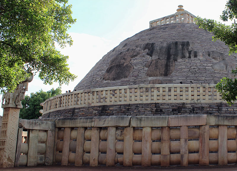
Stupas were burial mounds prevalent in India from the Vedic period. It is a conventional representation of a funeral cumulus in which relics and ashes of the dead were kept. During the period of Ashoka, the art of stupas reached its climax. Almost 84,000 stupas were erected during his period
1.1 Elements of a Stupa Architecture
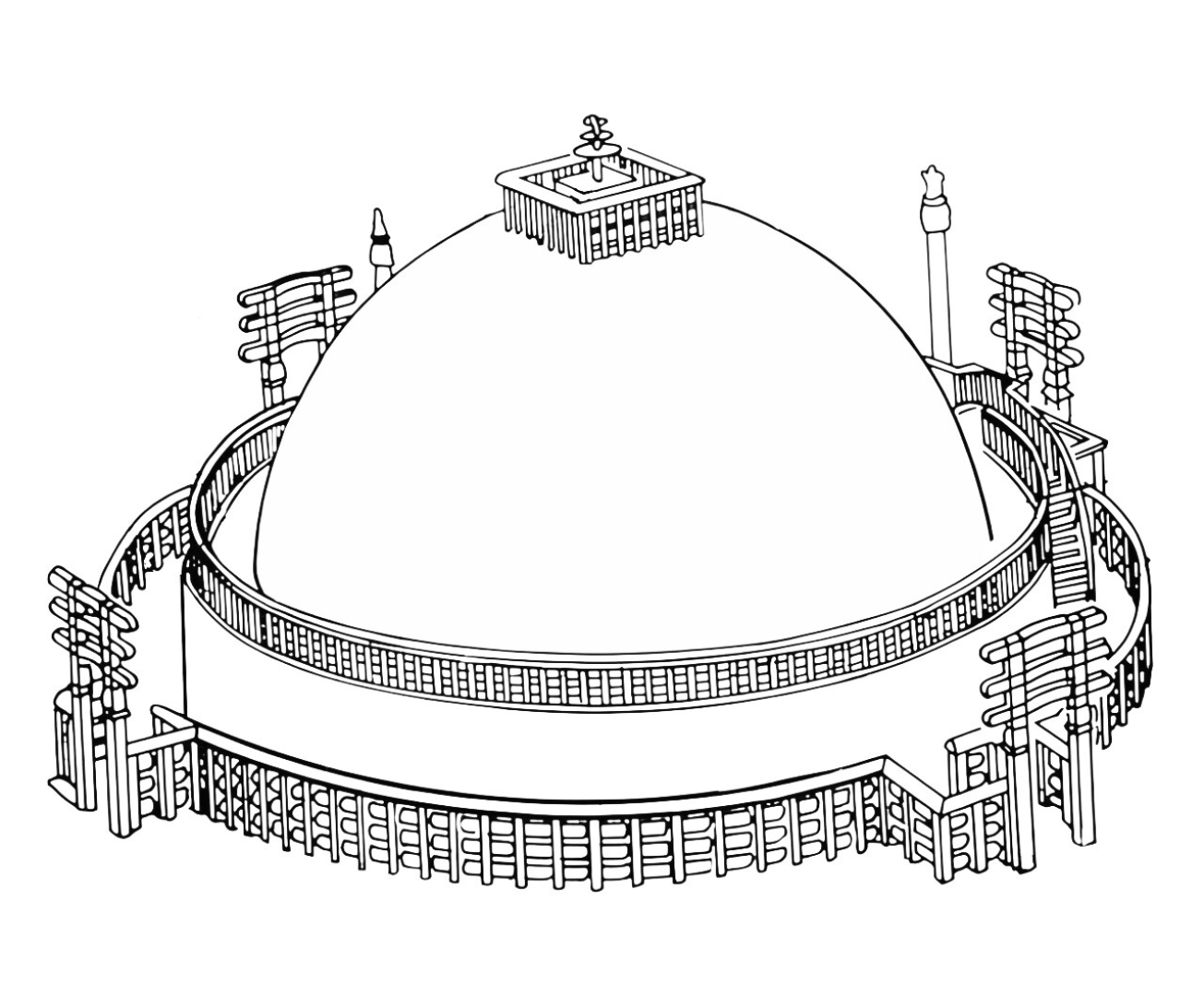
Anda

Toran
A toran of a stupa is an ornate, ceremonial gateway
marking the entrance, typically consisting of two
pillars and horizontal beams, elaborately carved with
Buddhist stories (like Jataka tales) and symbols,
serving as a sacred, symbolic passage to enlightenment,
famously seen at the Great Stupa in Sanchi.
The cardinal directions for stupa toranas are the North,
South, East, and West, each marking a significant event
in the Buddha's life: East for his Birth, South for
Enlightenment, West for his First Sermon, and North
for his Nirvana (death).
Note: The elaborately carved gateways were added later
(by Satvahanas) in the 1st century BC.

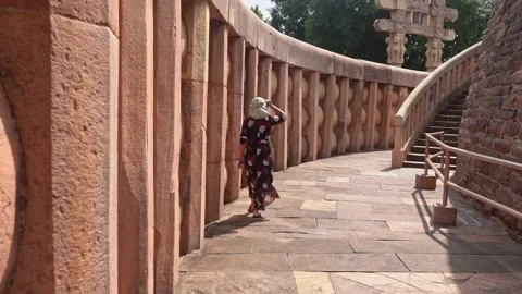
Medhi
The Medhi is a crucial part of a stupa, a raised,
circular terrace or platform built around the base of
the dome (Anda) that serves as the primary path for
devotees to perform ritualistic clockwise
circumambulation (Pradakshina patha) as a meditative
act of reverence
Vedika
The vedika of a stupa is the sacred, low stone or wooden
railing that encircles the monument, defining its holy
boundary and separating it from the secular world, often
featuring elaborate carvings of Buddhist tales and
symbols, with ceremonial gateways (toranas) at the
cardinal points for circumambulation
Harmika

Yasti
The yasti in a stupa is the central spire or mast rising
from the top of the dome (anda), symbolizing the axis
mundi (cosmic axis) connecting earth and heaven, often
surrounded by a railing (harmika) and topped by
ceremonial parasols (chhatras)
Chatras
Chatras are tiered, umbrella-like finials symbolizing
royalty, protection, and spiritual ascent, placed atop
the yasti (spire)
Pradikshina Path
Pradakshina Patha in a stupa is the circular, processional pathway around its base, where devotees walk clockwise (Pradakshina or Parikrama) as a meditative ritual of reverence, symbolizing the journey of the soul, often enclosed by railings (vedika)
Introduction
Vedika, meaning “railing” or “raised platform” in Sanskrit and Pali, is a prominent architectural feature of Buddhist stupas.
Purpose
It functions as a boundary, separating the sacred space of the stupa from the mundane world, and also facilitates circumambulation (walking around the stupa in a clockwise direction) for worshippers.
Construction and Decoration
Vedikas are typically constructed with vertical pillars (stambh) and horizontal bars (suchi). Vedikas often feature intricate carvings depicting religious iconography, mythological events, and protective deities.
Introduction
In a stupa, the “medhi” is a raised terrace or platform, often enclosed by a railing
Purpose
It serves as a foundation for the dome (Anda) and a platform for devotees to walk around.
Construction
Medhi of a stupa is square or rectangular shaped slab
Introduction
It’s the solid, hemispherical dome that sits atop the base of the stupa.
Purpose
The anda encloses a relic chamber (tabena) containing actual relics of the Buddha or symbols.
Construction
Vedikas are typically constructed with vertical pillars (stambh) and horizontal bars (suchi).
Decoration
Vedikas often feature intricate carvings depicting religious iconography, mythological events, and protective deities.
Introduction
The Terekhol or Tiracol River is a river in western India. In its upper reaches it is known as the Banda River and in the lower reaches as the Tiracol.The length of this river is 27.5 km.
Origin and Flow
The Terekhol rises in the environs of the Manohargad in the Western Ghats and flows in a south-westerly direction It forms the boundary between Sindhudurg district of Maharashtra state and North Goa district of Goa state for some distance. It Enters Goa from the north 📍 near Patradevi. It Empties at 📍
Basin and Tributaries
The main tributaries of the Terekhol River in Goa are Torxe, Khadshi, and Pedne
Other Features
The historic fort of Terekhol is located on its right bank.
Introduction
The Talpona River is a river in the state of Goa, India that is a lifeline for the Canacona region, The river is about 41 kilometers long
Origin and Flow
The river originates in the jungles of Ravan Dongar in the Sahyadri Mountains and flows into the Arabian Sea.
Basin and Tributaries
The river has three tributaries: Nadke, Gaondongrem, and Khalwade .
Other Features
The river has a unique ecosystem with mangroves, dunes, and a headland with a forest . The river has been polluted by household waste, plastic, and other debris
Introduction
The Galgibaga River is a river in South Goa, India that flows near Galgibaga Beach. The river is known for its mangroves and coastal vegetation.
Origin and Flow
The Galgibaga River originates in the hilly areas of the Uttar Kannada district of Karnataka.
Basin and Tributaries
The Galgibaga River is fed by the Mashe and Loliye rivers.
Other Features
The Galgibaga River is located near Galgibaga Beach, which is also known as Turtle Beach. The Galgibaga River has been affected by cyclones, including Cyclone Tauktae and Cyclone Vayu
Introduction
The Sal River The river is the third longest river in Goa, stretching 35 kilometers. It is located in the Taluka of Salcete, in the Indian state of Goa.
Origin and Flow
It Originates from a small spring in Verna Village, South Goa.
Basin and Tributaries
It has two tributaries, namely Navelim Nallah and Cincolim Nallah..
Other Features
The Sal River flows through urban areas like Verna, Madgaon, Navelim, and Benalulim
Introduction
The Saleri River is a river in Goa, India that flows into the Arabian Sea. It’s one of the 11 rivers that sustain Goa.
Origin and Flow
The Saleri River originates in the forest near the border of Barcem and Gokuldham villages in Quepem
Basin and Tributaries
The Padi and Molore rivers join the Saleri River
Other Features
The Saleri River, along with other rivers in Goa, provides potable water and supports the state’s ecosystems. The Saleri River is threatened by deforestation, agriculture, and other human activities
Introduction
The Mandre river originates from the jungle of Corgao. It flows through Mandre, Corgao, and finally unite with the sea after covering 8.75km distance.This river is projected to be extinct due to increased human activities near the river.
Introduction
The Harmal river originates in the Corgao. It flows for a distance of about 11 km in the west direction. Finally, it enters the Arabian Sea. The infrastructure projects undertaken for tourism purposes have adversely affected the river.
Introduction
The Baga river is the smallest river in Goa. It rises from the jungle of Assagao. A small stream of water from the Saligao hill meets the Baga river at Arpora. It is 10 km long. The river joins the Arabian Sea. Garbage disposal and sewerage treatment are the two main reasons for the pollution of the Baga river. Various tourism activities have seriously destroyed the river’s natural drainage.